OpenStreetMap Mapathon
Koerner Library
Room 217 GIS lab
Wednesday November 15th
3:30 – 4:30 PM
No registration necessary
Celebrate GIS day with an OpenStreetMap mapathon!
In this workshop you’ll learn how to add data to OpenStreetMap. You’ll add geographic information that will be free to for anyone to use and share, from humanitarian uses to smartphone apps.
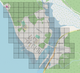
The workshop will focus on adding building footprints to Masset, BC on Haida Gwaii.
You’ll learn how to:
- Create an OpenStreetMap account
- Edit point, lines and polygons
- Add information about your additions
Your help will make this area better.
Why building footprints?
From “OSMGeoWeek mapathons support Building Canada 2020“:
“Building footprints and wheelchair attribute data are used to assess the city’s accessibility. Building data can be merged with property assessment data to visualize property assessment values, or it can be merged with zoning data to visualize allowed versus actual buildings heights.”
This OpenStreetMap Building Canada initiative has a vision of mapping all buildings in Canada by 2020. You can be a part of that.
Pizza will be provided.